
Restoring the Past: Breathing New Life Into the Laboucane Settlement Map (1883)
When one of my best friends, Will Laboucane, brought me a weathered scan of a historic land map connected to his family’s Métis heritage, I knew this wasn’t just a restoration job—it was a meaningful preservation of personal and regional history.
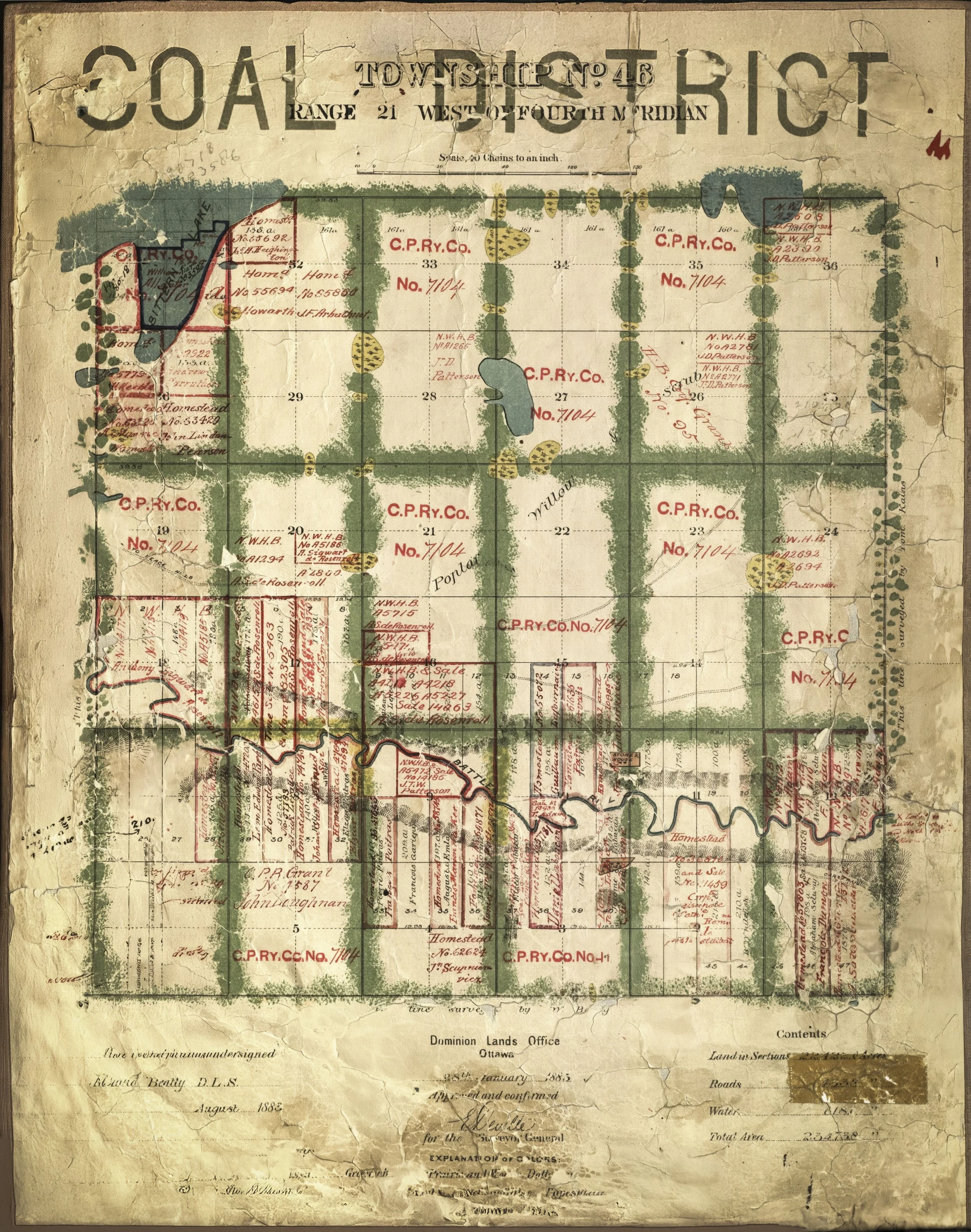
The original artifact, drafted in January 1883, depicted a section of what is now Duhamel, Alberta, but at the time was referred to as the Laboucane Settlement. This hand-drawn map is more than just a layout of land, it’s a record of legacy, a documentation of early homesteads, railroad claims, and the lives of Métis settlers like Will’s ancestors.
The Original Scan: Beautifully Broken
The original file showed its age in every corner:
Original Resolution: 797 x 1000 pixels
Original DPI: 72
Condition: Cracked edges, severe paper aging, faded ink, missing sections, and overall degradation from time and handling.
Despite the wear and tear, the spirit of the document was intact. My challenge was to restore and enhance the image for large-format art printing while maintaining the authenticity that makes these types of historical visuals feel real.
The Workflow: Where A.I. Meets History
This restoration leaned on a blend of cutting-edge AI tools and creative digital editing. Each tool played a critical role in the process:
Topaz Photo AI: Used to intelligently upscale the original scan while restoring fine details, preserving text, particularly in faded text and color transitions. Topaz's advanced denoising and sharpening were key to extracting clarity without artificial artifacts.
Adobe Photoshop & Generative Fill: Photoshop's Generative Fill helped patch the heavily damaged areas—reconstructing missing edges, blending worn sections, and filling in entire text segments using logical structure based on the rest of the image.
Adobe Lightroom: Lightroom was the final stop, where I tuned tonal contrast, added depth, and subtly enhanced texture and paper grain. This helped preserve that lightly aged, slightly cracked aesthetic while elevating the visual integrity.
The Result: Large-Format Worthy and Museum-Ready
Final Resolution: 9794 x 7722 pixels
Final DPI: 1524 (print-ready at ultra-high fidelity)
Output Quality: Archival quality, suitable for large-format printing or historical exhibition
We made a conscious decision to leave subtle wear and aging visible—creases, browning, and handwritten quirks—so the final piece still feels like something from 1883, not a sterile modern replica. Major damage was filled, but the patina of time remains.
A Historical Snapshot: The Laboucane Settlement
In the late 19th century, this area of Alberta was a hub for Métis families and a focal point for Canadian westward expansion. This map, issued by the Dominion Lands Office and signed in August 1883, shows plots granted to settlers, land retained by the C.P. Ry. Co. (Canadian Pacific Railway Company), and homestead applications along the Battle River. The Laboucane family name appears directly on the map—a rare and intimate thread tying family identity to geography.
The settlement itself—once named after Will’s family—has since evolved into Duhamel, Alberta, but the story etched into this paper remains unchanged.
Why It Matters
This project wasn’t just about clarity, resolution, or pixels, it was about honoring a legacy. In a world where history can be lost in forgotten drawers or pixelated scans, it’s vital to give personal heritage the space and respect it deserves.
Now, thanks to modern tools and a whole lot of careful work, Will has a stunning, high-resolution art piece that doesn’t just hang on a wall—it tells a story.
Links to Download the Original & Full Resolution Images Here.
The Original vs. Final Image

More of the History…
This restored map isn’t just a technical marvel — it’s a window into a powerful, often-overlooked chapter of Métis history in western Canada.
The area shown was originally known as the Laboucane Settlement, named for the Métis families who established trade routes and homesteads there as early as 1870. Located along the Battle River — a region named after conflicts between the Cree and Blackfoot nations — the land served as a vital corridor for buffalo hunters and merchants using the iconic Red River carts.
Among the most notable figures were François Gabriel Dumont and Abraham Salois, Métis buffalo hunters and community leaders who helped shape the early settlement. François was born at Old Fort Edmonton in 1825 and brought both the first plow and first priest to the region, helping launch agricultural and spiritual foundations in what would become Duhamel.
In 1878, six Laboucane brothers — Jean Baptiste, Gabriel, Elzéar, Jerome, Pierre, and Guillaume — traveled from White Horse Plain, Manitoba, and divided their settlement between the north and south sides of the Battle River. These families weren’t just homesteaders; they were pioneers of diplomacy, agriculture, trade, and cultural endurance.
The original name was eventually changed to Duhamel, in honor of Bishop Thomas Duhamel, after a mission was established there in 1881. Later, with the arrival of non-Indigenous homesteaders in the 1890s, many of the Métis families moved north to Saint-Paul-des-Métis — taking their herds, traditions, and stories with them.